Capri Landmark Urban Centre Plan
The Capri-Landmark neighbourhood, located between Gordon Drive and Spall Road, and Highway 97 and Springfield Road, is one of Kelowna’s major employment hubs and an attractive location for apartment living. On April 1, 2019, Council endorsed the Capri-Landmark Urban Centre Plan.
The detailed plan will guide redevelopment over the next 20 years and beyond, including the locations of parks and public spaces, development standards, and transportation solutions. The City of Kelowna would like to acknowledge the participation of local residents and landowners, community groups and general public who participated in helping develop the draft plan.
Check out this video to see how the preferred concept plan addresses future growth, how people will get around and where future residents and workers will access parks and public space.
Great urban centres result from careful planning, strategic investment and thoughtful development. The Capri-Landmark Plan is our first opportunity to apply the principles and targets of the Urban Centres Roadmap to an urban centre in Kelowna.
The Capri-Landmark Urban Centre Plan is a big step toward creating a successful urban centre that delivers a high quality of life for current and future residents and employees in the area.
The ambitious approach to parks, public space and transportation will require greater capital investment, as well as the implementation of a strategy for funding future infrastructure in the area as growth takes place. With a strong plan in place, each re-development proposal can be leveraged as an opportunity to invest in the area in a way that moves the community closer to the plan's vision.
Capri-Landmark was prioritized as the City’s first area for a detailed urban centre plan for two key reasons:
- Growing development pressure
- Infrastructure challenges resulting from a fragmented street network, discontinuous sidewalks and limited parks spaces in the Landmark District
Background | Concept planning | Preferred concept | Draft plan & transportation assessment | Final plan development |
| Feb. - March 2017 | April - July 2017 | Aug. - Oct. 2017 | Nov. 2017 - May 2018 | June 2018 - April 2019 |
When the planning process began in 2017, residents, businesses and workers in the Capri-Landmark area told us about what they love about the area and what they think needs to be improved. One thing was clear: the opportunity for transformation in Capri-Landmark got people excited. By the end of the process, hundreds of residents had provided their ideas about how to make the neighbourhood better as it grows.
- Encourage mixed-use residential development that balances jobs and residents in the area
- Add high-density residential in key locations to support the vitality of the area
- Ensure amenities with density and invest in green space as density increases
- Improve walkability, invest in sidewalks and break up larger blocks.
- Strengthen cycling connections to key destinations
- Improve transportation connectivity and traffic flow
- Maintain rental housing as the area densifies and revitalizes
- Work to develop Mill Creek and Ritchie Brook as natural assets to reduce flooding risks
- Strengthen the connection and access to Parkinson Recreation Park
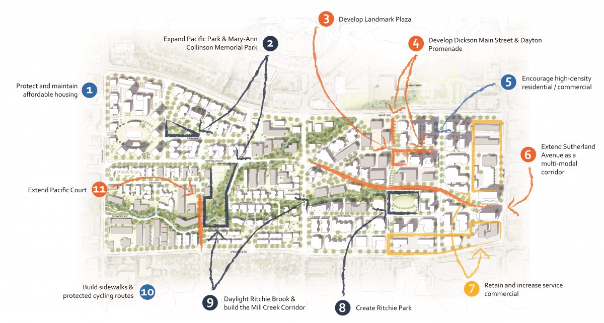
The image below summarizes some of the key recommendations on how the area could transform over the next 20 years or more.

This project is made possible with funding from:


